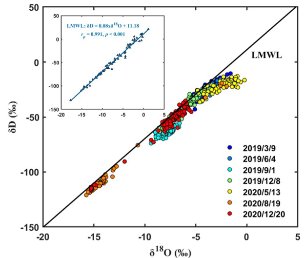
As an effective natural tracer, water stable isotopes have been increasingly used for understanding water exchanges across the land-atmosphere interface and identifying plant water use sources; however, the characteristics of their spatiotemporal variations in soil water remain poorly understood, which may lead to large uncertainties in interpretating the data on soil water stable isotopic compositions (SWSIC; e.g., δD, δ18O, and lc-excess) for various research and application purposes.
To resolve this issue, a research team led by Prof. Tiejun Wang from School of Earth System Science at Tianjin University carried out long-term field campaigns to study the spatiotemporal characteristics of SWSIC variations under different land surface conditions. Soil water samples with high spatial resolutions (~5 m between neighboring sampling points) were obtained from a reforested karstic site in southwest China and an agricultural field located in North China Plain.
The results from both study sites showed that (1) even at field scales (~100 m), for instance, δD values could vary up to 55.2‰, demonstrating the complexity of SWSIC dynamics at small spatial scales; (2) compared with soil water content (SWC), SWSIC tended to display spatial structures of low temporal stability, implying that the interactive effect of land surface processes (e.g., soil evaporation, rainfall infiltration, and soil water mixing) on SWSIC could vary considerably over time; and (3) the spatiotemporal patterns and their controlling factors were noticeably different between SWSIC and SWC, suggesting that the knowledge gained from numerous SWC studies might not be directly transferred to understand SWSIC spatiotemporal characteristics. However, the study also showed that the temporal stability analysis method initially proposed for studying SWC could be extended to select representative sites for monitoring areal average SWSIC, due to the temporal persistence of the SWSIC spatial structures. These findings have important implications for designing SWSIC monitoring schemes, which in turn can improve the interpretation of SWSIC data for understanding various ecohydrological and land surface processes.

Figure 1. Dual isotope plot of soil water samples, where LMWL is the local meteoric water line
This work was supported by the National Natural Scientific Foundation of China (42171036, U1612441), and related publications are listed as following:
(1) Liu Q, Wang T*, Liu C, Mikouendanandi E. M. R. B., Chen X, Peng, T, Zhang, L. Characterizing the spatiotemporal dynamics of shallow soil water stable isotopic compositions on a karst hillslope in Southwestern China[J]. Journal of Hydrology. 2022, 610: 127964. https://www.sciencedirect.com/science/article/pii/S002216942200539X
(2)Xu M, Liu Q, Wang T*, Wu D, Mikouendanandi E. M. R. B., Qi C. Characterization of spatiotemporal patterns of soil water stable isotopes at an agricultural field[J]. Science of The Total Environment. 2022, 828: 154538. https://www.sciencedirect.com/science/article/pii/S004896972201631X