Dr. Yonggen Zhang recently published a paper entitled “A High-Resolution Global Map of Soil Hydraulic Properties Produced by a Hierarchical Parameterization of a Physically-Based Water Retention Model” in Water Resources Research regarding the recent advances in global parameterization of soil hydraulic parameters.
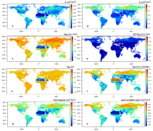
A correct quantification of mass and energy exchange processes among Earth’s land surface, groundwater and atmosphere requires an accurate parameterization of soil hydraulic properties. Pedotransfer functions (PTFs) are useful in this regard because they estimate these otherwise difficult to obtain characteristics using texture and other ubiquitous soil data. Most PTFs estimate parameters of empirical hydraulic functions with modest accuracy. In a continued pursuit of improving global-scale PTF estimates, we evaluated whether improvements can be obtained when estimating parameters of hydraulic functions that make physically-based assumptions. To this end, we developed a PTF that estimates the parameters of the Kosugi retention and hydraulic conductivity functions (Kosugi 1994, 1996), which explicitly assume a lognormal pore-size distribution and applies the Young-Laplace equation to derive a corresponding pressure head distribution. Using a previously-developed combination of machine learning and bootstrapping, the developed five hierarchical PTFs allow for estimates under practical data-poor to data-rich conditions. Using an independent global dataset containing nearly 50,000 samples (118,000 retention points) we demonstrated that the new Kosugi-based PTFs outperformed two van Genuchten-based PTFs calibrated on the same data. The new PTFs were applied to a 1×1 km2 global map of texture and bulk density, thus producing maps of the parameters, including residual water content, saturated water content, saturated hydraulic conductivity, as well as field capacity, wilting point, plant available water, and associated uncertainties. Soil hydraulic parameters exhibit a much larger variability in the northern hemisphere than in the southern hemisphere, which is likely due to the geographical distribution of climate zones that affect weathering and sedimentation processes.
The dataset provides parameters models to estimate moisture content, such as in soil water balance models, hydrological and ecological models, crop growth models, agro-ecosystem model, land surface models, weather forecast models, air quality models, and global climate models.
The work is supported by National Natural Science Foundation of China (grant 41807181). These new pedotransfer functions were written in Python programming; the source code and additional documentation as well as global maps (in GeoTIFF format, which can be read by R, python, Matlab and most GIS software) of the five Kosugi parameters, field capacity, wilting point, plant available water, and associated uncertainties on the surface soil in 1 km resolution can be downloaded from https://dataverse.harvard.edu/dataset.xhtml?persistentId=doi:10.7910/DVN/UI5LCE.
For the full access to the paper, please find the link here: https://agupubs.onlinelibrary.wiley.com/doi/abs/10.1029/2018WR023539

Figure Global map of (a) residual water content (θr), (b) saturated water content (θs), (c) log10(hm), (d) standard deviation of log10(hm), (e) log10(σ), (f) saturated hydraulic conductivity (log10(Ks)), (g) field capacity (h = 330 cm), and (h) plant available water (field capacity minus permanent wilting point) in 1 km resolution estimated from Kosugi K3 model (using sand, silt, clay percentage, and bulk density as input). Calculations are based on the surface soil of SoilGrids 1 km data set (Hengl et al., 2014).