The Red River fault, one of the most important high-strain structures in Southeast Tibet, experienced a kinematic reversal, but the exact timing and mechanisms remain debated. The Dali normal fault system, situated at the northwestern end of the Red River fault, is kinematically linked to the right-lateral Red River fault (Fig. 1). This linkage provides an excellent opportunity to unravel the timing of tectonic inversion. The Dali fault system also cuts across the hairpin-shaped reach of the Jinsha River, and its impact on river development remains poorly understood.
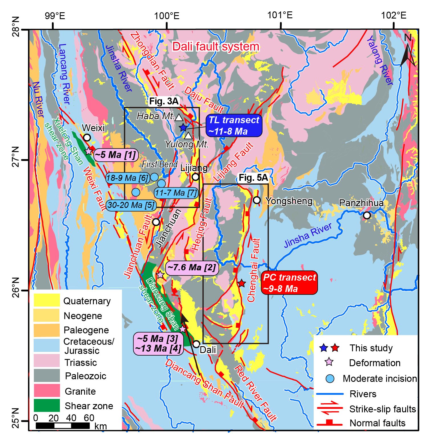
Fig. 1 Simplified geological map of the Dali fault system in Southeast Tibet.
To address these issues, Prof. Jing Liu-Zeng's research group, in collaboration with domestic and international institutions, focused on two major branches of the Dali fault system (the Daju-Lijiang and Chenghai faults). By employing zircon fission-track (ZFT) and apatite (U-Th)/He (AHe) low-temperature thermochronology, combined with thermal history modeling, tributary river profile analysis, and field observations, the study systematically revealed the tectonic inversion and associated geomorphic responses of the Dali fault system.
The results indicate that the footwalls of the Daju-Lijiang and Chenghai faults experienced rapid exhumation starting at 11-8 Ma and 9-8 Ma, respectively, marking the onset of normal faulting activity (Fig. 2). The normal faulting activity along the Daju-Lijiang fault since ca. 11-8 Ma neatly explains spatial and temporal variations in river incision between Tiger Leap Gorge and First Bend, which were influenced by oroclinal bending on the footwall (Fig. 3). Furthermore, tributary river profile analyses and geomorphic features show significant differences along the two sides of the Chenghai fault, a finding that provides robust evidence for the role of normal faulting in driving differential incision of the Jinsha River.
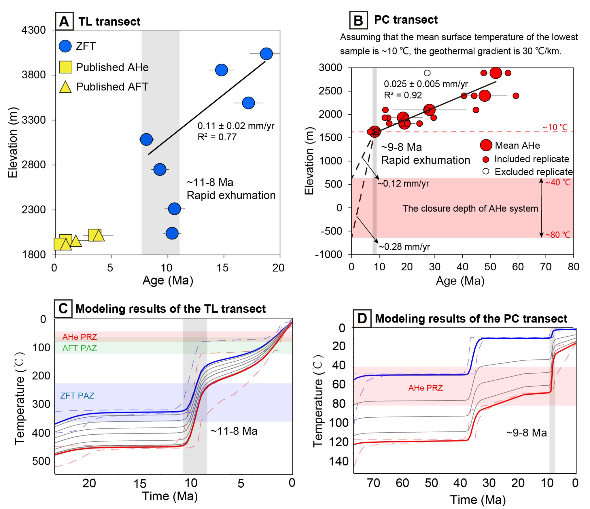
Fig. 2 Age-elevation relationships and thermal modeling results for the footwalls of the Daju-Lijiang and Chenghai faults.
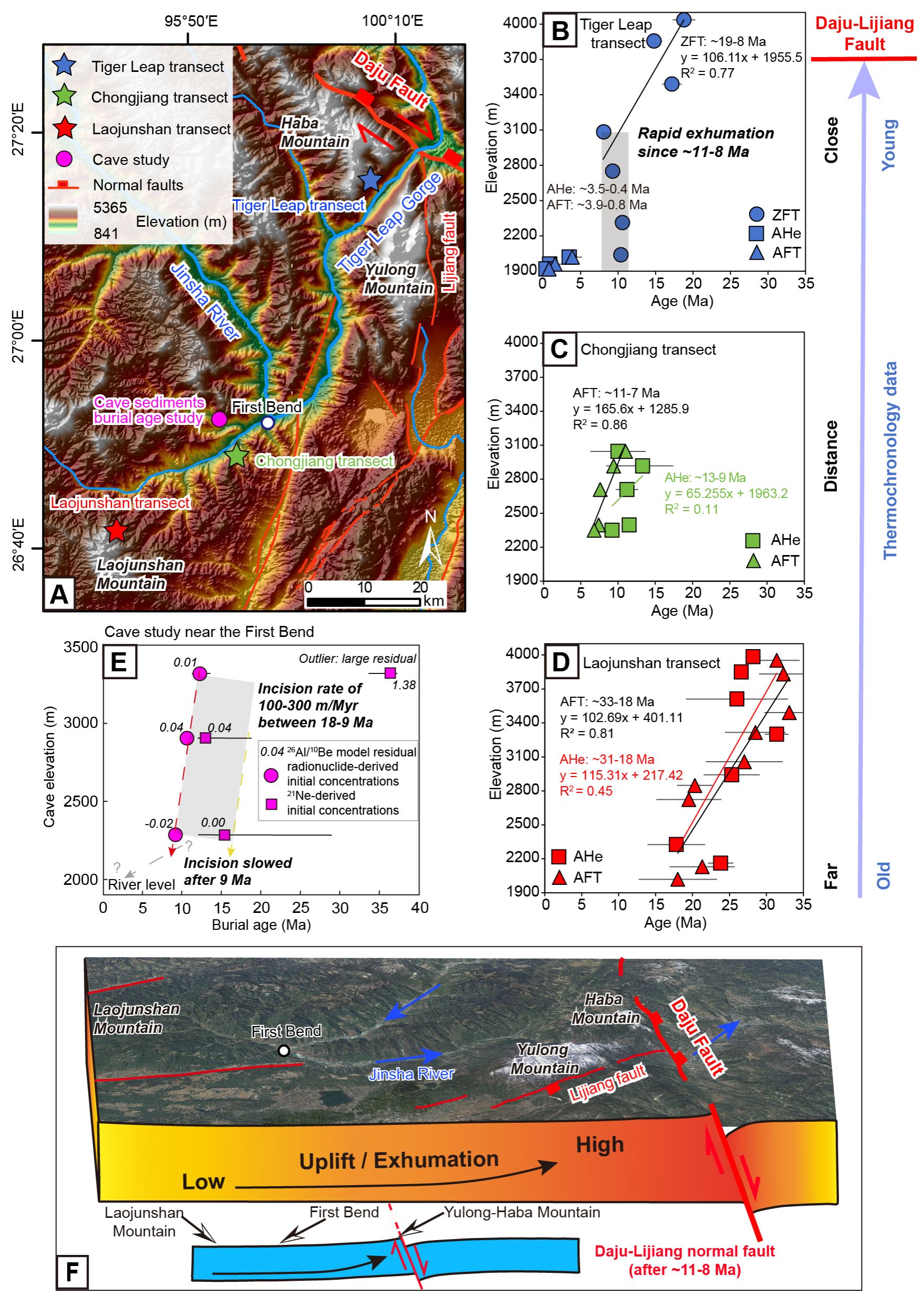
Fig. 3 Late Miocene normal faulting of the Daju-Lijiang fault controlling differential river incision in the First Bend of the Yangtze River and the Tiger Leap Gorge.
Integrating published data, this study reveals that northwestern Yunnan predominantly underwent nearly east-west transpressive deformation from the Oligocene to the early/middle Miocene, transitioning to nearly east-west extension during the Late Miocene (ca. 11-7 Ma), which signifies tectonic inversion (Fig. 4). The extensional deformation of the Dali fault system not only controlled the geomorphic evolution of the Jinsha River but also directly influenced the basin-and-range landscape of northwestern Yunnan. Moreover, the late Miocene extension of the Dali fault system provides further evidence for the middle-late Miocene tectonic reorganization within the Chuan-Dian Block in southeast Tibet.
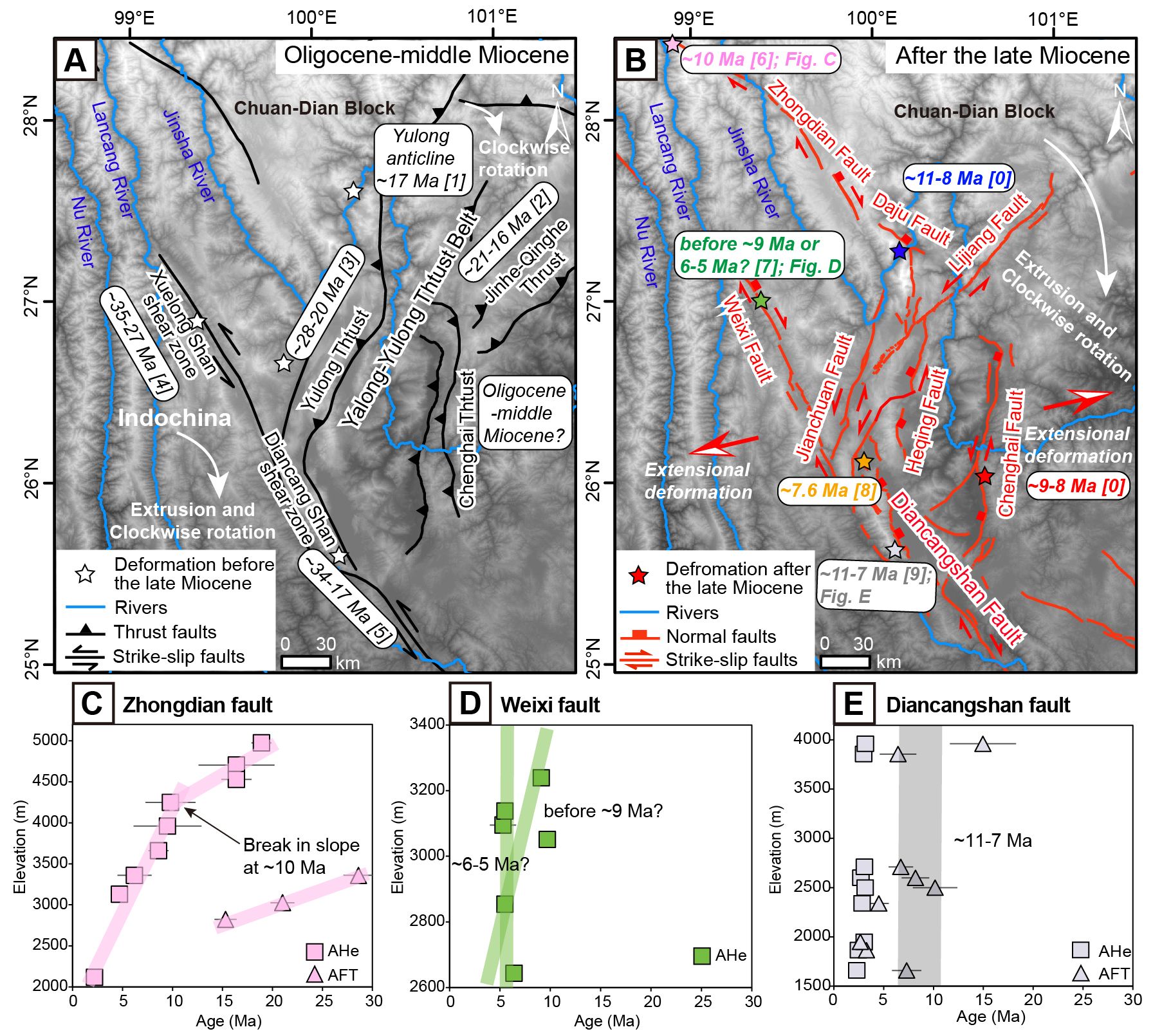
Fig. 4 Late Miocene tectonic inversion of the Dali fault system.
This study has been published in the Geological Society of America Bulletin under the title "Late Miocene extension of the Dali fault system in Southeast Tibet: Coupled tectonic inversion and landscape evolution." The paper is authored by Xuwen Shen (first author, a PhD student at the School of Earth System Science, Tianjin University), Jing Liu-Zeng (corresponding author), Xiaoming Shen (National Institute of Natural Hazards), Kai Cao (China University of Geosciences, Wuhan), and Philippe Hervé Leloup (Université Claude Bernard Lyon 1), among others.
Source:Shen, X., Liu-Zeng, J.*, Shen, X., Cao, K., Leloup, P. H., Qin, K., Xing, Y., Li, J., Zeng, X., Wang, H. Late Miocene extension of the Dali fault system in Southeast Tibet: Coupled tectonic inversion and landscape evolution. Geological Society of America Bulletin, 2025. https://doi.org/10.1130/B38058.1.